Like most businesses these days, trucking companies are looking to do more with less.
Over the last year, more fleets took to optimizing their operations to counter record prices at the pump and higher costs across the board due to inflation. For fleets, that meant planning better routes, optimizing hubs for shorter trips, reducing vehicle idling, and relying on data to reduce downtime, according to Geotab’s inaugural 2023 State of Commercial Transportation report.
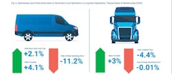
Geotab, which collects data from 3.2 million connected commercial vehicles across the globe—with a heavy emphasis on the North American market—found that in 2022, there was an increase in fleets’ average daily trips by 5.64%, yet a decrease of 7.71% in average vehicle operating hours compared to the previous year.“[Fleets] are finding opportunities to service their customers in a more efficient manner, meaning less hours on the road, less distance being traveled, but more trips being made,” Geotab stated in its report. “This is a pattern that we have observed across nearly every one of the top 10 industries serviced by Geotab—leading to a general trend of ‘do more with less.’”
Moving ahead in 2023, Geotab is hoping to further develop its capabilities to help fleets enhance safety, reduce downtime, and move the needle on transportation decarbonization. That, however, cannot be accomplished without having access to quality data, noted Mike Branch, Geotab’s VP of data and analytics, during the Geotab Connect 2023 conference in Orlando, Florida.
“We’ve all seen issues when we don’t have really good quality data,” Branch said. “The quality of data matters so much in everything we do. It powers our AI and the intelligence that we have behind our systems.”
See also: Geotab integrates with Cummins, adds curated data tool for fleets
When it comes to data and AI in 2023, Branch said Geotab will:
- Implement AI infusions through all its applications—everything from electrical systems ratings to fuel issues and engine coolant issues.
- Introduce an Optimization Engine to power fleet operations. That tool, according to Geotab, looks at fleet optimization holistically. “It’s about getting the right driver with the right qualifications to the right location at the right time and the right cost,” Branch said, adding the offering will be introduced into the next release of MyGeotab.
- Infuse video into everything. “We have to have video and treat is as a first-class citizen within MyGeotab, working very closely with our video partners to ensure there is a seamless experience,” Branch noted. “That seamless experience goes beyond just having the video in MyGeotab, it’s about the insights from that video funneled up in our entire ecosystem.”
- Simplify access to data. Geotab has started down that journey with the recent announcement of its Data Connector, an integrated intelligence tool designed to help fleets address rising operating costs and supply chain, talent, and regulatory pressures. Geotab has curated specific data sets and made that data accessible through a "no-code" integration with a fleet’s preferred business intelligence tool, such as PowerBI, Tableau, or Excel. Data sets can then be integrated with fleet data from other sources such as maintenance or accounting systems.
Leveraging data to drive fleet sustainability
Last spring, Geotab partnered with The Ray, a nonprofit near-zero emission highway testbed, to illustrate how data-driven analysis of truck movement patterns can help guide state departments of transportation when they begin planning and funding electric vehicle charging infrastructure.
The Ray, utilizing Geotab telematics, aims to support states and local governments as they seek to determine the optimal locations and design for charging stations for both passenger and freight vehicles. By observing real truck movement data, The Ray intends to recommend where and what type of additional truck parking is needed for electrification.
The initial analysis was performed by The Ray and Geotab on two pilot corridors: one regional route along I-20 from Dallas to Atlanta, and one local route from the Port of Savannah, Georgia, to the inland port in Atlanta. Geotab developed and provided data visualization tools, such as graphs and heat maps, allowing The Ray to dial into the analysis and leverage data insights along the two corridors. The analysis demonstrated different observed truck movement patterns for each of the two corridors. The regional route along I-20 revealed vehicles stopped at many, inconsistent locations along the entire route, while the local route revealed vehicles stopped at just a few distinct locations.
See also: Charging infrastructure holds back EV truck production, deployment
This strategic planning approach also gives states the opportunity to overlay Geotab’s data analysis with The Ray’s GIS roadside solar tool to identify optimal locations for the development of roadside solar. Utilizing the tools together, state DOTs can connect the demand of high-powered EV charging stations with the potential production of right-of-way solar.
“Findings from our pilot corridors underscore the need for data from additional corridors throughout the country to set states up for success,” Allie Kelly, executive director of The Ray, said in a press release. “The telematics technology from Geotab, together as an overlay to The Ray’s solar mapping tool, will help transportation planners start one step ahead by developing infrastructure how and where it’s needed most, and determining which locations are optimal for co-locating EV charging and solar arrays on the roadsides.”
During the Geotab Connect 2023 conference, the telematics provider also unveiled a new electric vehicle range analysis, which examines the impact of speed and temperature on EV range.
From its analysis, Geotab observed that the speed at which vehicles drive influences the relative impact of temperature. At low speeds, temperature can significantly impact range, and at higher speeds, temperature becomes much less relevant, the company pointed out. The size and shape of the vehicle also influence the optimal conditions to maximize EV range, and larger vehicles lose range more quickly with increased speed.
For a highway route, avoiding speeding will be the best strategy to conserve range, especially for larger vehicles, Geotab stated. For slower routes, there will be more seasonal variability in range, so mitigating the impact of temperature will have the best results, the company added.Matt Stevens, who is on Geotab’s Board of Advisors, said that more and more businesses and industries have already begun reporting their carbon footprint and figuring out how they can reduce their emissions.
“We think over the next few years, that will become the norm,” Stevens noted. “There’s a lot you can do with the fleet you already have. There is no one-size fits all in fleet sustainability. Good data coupled with AI will be a powerful tool for your journey.”


