How to optimize transit asset management with GIS-enabled digital twins
Integrating geographic information systems with digital twin technology marks a pivotal advancement in transit organizations’ asset management. This fusion delivers a powerful digital model of physical assets and their environments, enabling agencies to tackle urban mobility complexities with precision and data-driven insights.
For prominent agency chief operating officers and transit operations executives, GIS-digital twin technology offers opportunities for optimizing asset management, enhancing operational efficiency, and enabling predictive infrastructure and resource allocation planning.
The power of spatial intelligence and GIS-digital twin integration
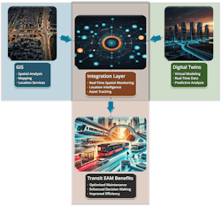
At the heart of GIS-digital twin integration lies a sophisticated spatial intelligence framework. GIS delivers geospatial data and real-time positioning that enhance digital twins, making them responsive to the spatial dynamics of transit environments.
Through IoT sensors and advanced data processing, GIS-enabled digital twins capture real-time interactions between assets and their environment, revealing insights into vehicle locations, infrastructure health, and operational anomalies. Equipped with 3D modeling and continuous data updates, digital twins facilitate advanced spatial analysis, converting raw data into actionable intelligence.
This capability allows users to visualize asset conditions, monitor vehicle fleet performance, and forecast maintenance needs by analyzing patterns in geographic data. These insights improve operational efficiency, reduce resource waste, and enhance service reliability.
Key applications of digital twins technology in transit asset management
Knowledge is power for transit asset management. GIS technologies can help optimize operations in myriad ways, including:
- Predictive maintenance: GIS-enabled digital twins create virtual replicas of physical assets that continuously monitor and analyze performance in real geographic contexts. These models leverage spatial data to understand how environmental factors affect asset health, from urban pollution impacts to weather-related stress. For example, spatial trend analysis reveals that coastal assets often require specialized maintenance schedules due to humidity-related wear.
The virtual models provide a visualization of asset data, enabling maintenance teams to quickly comprehend environmental impacts and make informed decisions about preventive strategies, ultimately optimizing asset lifecycles while reducing operational costs. - Operational optimization: GIS-enabled digital twins can create dynamic virtual models that analyze spatial networks in real-time. These systems combine location data with real-time operational metrics to optimize route planning and resource allocation. The integration enables precise tracking of asset movement patterns, traffic conditions, and demand fluctuations across geographic areas.
By leveraging spatial intelligence, organizations can implement automated adjustments to operations, optimize resource deployment, and align service delivery with demand patterns, ultimately reducing operational costs while improving service efficiency. - Real-time fleet performance monitoring and analysis: GIS-enabled digital twins can create comprehensive virtual replicas that track and analyze vehicle operations in real geographic contexts. These intelligent models combine real-time vehicle telemetry with spatial data to understand performance patterns across routes and conditions. For example, digital twins can identify how specific geographic factors like terrain, traffic patterns, and weather impact fuel efficiency and vehicle wear.
The technology could enables operations teams to optimize route planning, reduce fuel consumption, and enhance vehicle utilization through data-driven decisions based on location-specific intelligence.
See also: AI's role in predictive maintenance
Implementation strategy for GIS-digital twin integration
Successful GIS-digital twin integration requires users to establish data standardization and system interoperability protocols for enterprise asset management. This process involves consolidating disparate data sources into a unified, GIS-enabled digital twin platform, which may require cloud and edge computing resources to manage extensive datasets in real-time. Standardizing data formats, such as adopting Open Geospatial Consortium standards for GIS, ensures seamless integration and high-quality data. Moreover, implementing robust data security and privacy measures, including encryption and identity management, is essential to safeguarding sensitive operational data.
Cross-departmental collaboration is crucial for maximizing the benefits of GIS-digital twin technology. Organizations can foster widespread acceptance and optimize the technology’s impact by developing GIS expertise across teams and providing user-friendly analytic tools. Training programs in spatial analytics and maintenance drills using digital twins close skill gaps, enabling operators to use these tools effectively without assistance. Clear performance metrics are also vital since they allow agencies to measure the success of GIS-digital twin integration and drive continuous improvement.
Strengthening decision-making and real-time analytics
One of the most transformative aspects of GIS-enabled digital twins is their role in enhancing decision-making. Synthesizing real-time spatial data with operational information empowers agencies to make timely operational adjustments, such as rerouting to avoid traffic or modifying maintenance schedules based on real-time asset conditions. Additionally, in strategic planning, spatial analytics informs infrastructure investments, capacity forecasting, and asset replacement prioritization. This capability helps agencies align resources with projected urban development.
Future trends and technology innovation
As GIS-enabled digital twin technology evolves, several emerging technologies are poised to amplify its capabilities. Integrating artificial intelligence and machine learning enhances predictive analytics, enabling digital twins to anticipate and model complex patterns in asset performance and maintenance needs. When combined with augmented reality interfaces, IoT-enabled networks can deliver real-time, spatially accurate data to field technicians, streamlining maintenance and reducing response times.
Developing universal standards and interoperability frameworks will further elevate the utility of GIS-enabled digital twins, enabling transit agencies to scale systems and foster industrywide collaboration.
Unlocking strategic value through spatial intelligence
GIS-enabled digital twins offer a robust approach to managing complex asset portfolios for users. This technology is more than a practical tool for large transit agencies; it’s a strategic asset that supports operational excellence and informs long-term planning.
As smart cities and data-driven infrastructures reshape urban landscapes, organizations that adopt GIS-enabled digital twins will be at the forefront of resilience, operational excellence, and strategic foresight. This technology positions transit organizations to visualize, predict, and meet future challenges and capitalize on opportunities, ensuring tangible, sustainable, efficient, and responsive service delivery in an increasingly interconnected world.
About the Author

Suhel Soudagar
Suhel Soudagar is a strategic technology consultant specializing in geospatial systems and enterprise digital transformation. He has pioneered the integration of advanced geospatial technologies with Enterprise Asset Management frameworks, delivering measurable improvements in asset tracking efficiency and operational analytics.

