Any fleet knows that bad weather can torpedo delivery times while putting cargo, equipment, and the lives of truck drivers at risk. That’s why there’s been a push in recent years to plug real-time weather information into trucking telematics so routes can be adjusted in case heavy rain, blizzards, and other inclement conditions make certain roadways too dangerous to traverse.
But real-time weather-data can also be used to aid fleets in accident reconstruction and crash-related insurance claims as well – expanding the potential return on investment (ROI) for such technology.
Fleet Owner spoke to Mark Hoekzema, chief meteorologist and director of meteorological operations at Earth Networks, about the potential uses of weather-data in trucking not only to help motor carriers improve efficiency and make their operations safer, but to also provide a “fuller picture” of what truck drivers must often push through in their daily routines as well.
Why is the need for ‘real-time’ weather data becoming so critical among trucking companies?
Time is critical for moving products and services across the country. Traffic flow is greatly affected by weather and weather can change in an instant. Knowing where rain, lightning, high winds, and other severe weather are occurring or threatening to develop can save valuable time, fuel costs and improved safety when used for route planning and adjusting.
Frost & Sullivan reports that telematics devices are enabling fleets to reduce fuel costs by as much as 25%, with a 30% reduction in idle time. And one of the most intriguing areas of innovation for fleet telematics can be found among the growing number of organizations leveraging advanced weather data to monitor deteriorating road conditions, hail and other weather hazards to optimize fleet operations and mitigate risk.
The power of weather-driven telematics is amplified when external weather data is combined with road conditions data to provide a real-time snapshot of driving conditions.
By integrating forecast models with surface observations and road observation, including pavement temperatures, road conditions, and road treatment in each area, companies can improve fleet routing through enhanced efficiency and safety – while better managing loss prevention that can occur due to hazardous driving conditions.
How can fleets bring such meteorological data into their route development processes?
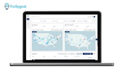
Fleet managers can tap into the benefits [of weather data] through weather visualization applications, typically web-based, that overlay weather data with road condition information for fleet operators to make intelligent weather-related decisions.
The ability to overlay real-time and forecasted weather data such as snow, hail, temperature, wind speed, lightning, wind gusts, etc. with road surface conditions holds the potential to significantly improve fleet operations, routing efficiency, and driver safety.
Fleet managers can have access to visualization tools with an extensive set of sophisticated weather observation layers with the weather data referenced above, as well as predictive weather alerts from the National Weather Service or commercial data providers such as Earth Networks.
Is it expensive to obtain this type of weather data?
Detailed weather forecast and data services are shown to save fleet operators many times over the cost for the services provided. Services can be tailored for virtually any budget, while still providing the operational cost savings and safety improvements.
What technology does a fleet need have in place to make use of it?
A fleet can use existing technology in most cases that allow new data sets to be ingested. In our example, a company would use our Sferic API [application program interface] to pull weather information into an existing fleet management operations application. If one doesn’t exist, fleet managers can use products directly from weather providers such as Sferic Maps and Sferic Mobile.
At the same time, customizable desktop and mobile device alerting capabilities notify fleet managers in real-time when weather threats impacting their operations are occurring. And with this data in hand, weather data visualization tools ensure that decisions are not made in a vacuum; fleet managers can use the data at their fingerprints to collaborate with stakeholders during severe weather events.
In many cases, fleet managers already operate a visualization platform that they distribute to their field staff to help them with routing and decision-making. These platforms may come prepackaged with data such as routing maps, as well as dynamic data that includes traffic congestions on their route – just like many of us see on Google Maps or Waze.
Whether they use a third party platform to aggregate and analyze this data or use a homegrown system, they can benefit from the flexibility to integrate weather data into these systems.
Leveraging off-the-shelf APIs that plug weather intelligence directly into existing systems alleviates the hassle of data management and allows fleet managers to effectively distribute relevant information to the right people.
Ultimately, how do fleets generate an ROI from piping real-time meteorological data into their telematics systems?
In some instances, you may want to send alerts of potentially hazardous storms for drivers to determine their best course of action. Alternatively, the weather data can be combined with other data sources such as traffic patterns and road closures to automate those decisions and simply present the optimized route to the driver that reduces delays, saves fuel costs, and adheres to committed delivery schedules.
Industry leading weather APIs offer real-time weather information for specific roadways and delivers hourly forecasts utilizing leading-edge predictive models that minimize errors and can be relied upon for operational decision-making.
Additionally, weather data – in conjunction with vehicle data – can assist fleet managers when it comes to accidents and other issues for which insurance coverage comes into play.
Historically, data-driven evidence has been elusive in determining the causes of accidents. It has largely been opinions of people involved in the incident and studying the damage for clues as to what happened.
Accident reconstruction is new data-driven approach to investigating the causes of accidents and ultimately who is responsible for paying for the damage, with insurance carriers starting to use mobile applications that track the speed and velocity at the time of the accident. They are also incenting policyholders to install tracking devices that provide more accurate measurements of the vehicle’s speed and other diagnostics.
However, speed and truck-sensor measured data is only meaningful with the proper context – particularly in terms of the weather and road conditions at the time of the incident. Painting the full picture takes claim validations to a new level, leveraging data to make decisions – not opinions.
The ability to understand if a driver was struggling through heavy rain and lightning is an entirely different set of data points than just the typical driver speed and time of day/night.


